Fixing The Damn Roads
It's been a challenge for the county road commission since 1919. The problem has always been money.
The Washtenaw Alano Club
Since 1969, the Washtenaw Alano Club (WAC) has fulfilled its mission “to provide a facility and environment conducive to spiritual growth for recovery from addictive behavior” by hosting a variety of 12-step recovery groups and offering social, educational, and recreational activities.
WAC currently serves 1,500 visitors each week over the course of 72 meetings covering eighteen distinct 12-step programs. Among these are: Al-Alanon, ACOA, AlaTeen, Narcotics Anonymous, Sexaholics Anonymous, Gamblers Anonymous, and Artists Recovering Through the Twelve Steps.
History & Founders
WAC was founded in 1969 through the efforts of a group of people in recovery who decided Ann Arbor needed its own Alano Club. WAC is currently one of numerous Clubs nationwide that host regular meetings and other social events for people in recovery. Some of the early community leaders and members who played a role in establishing WAC are: Leo H. Evans, Grace J. Yesley, Allen L. Rendel, Richard Hammerstein, Judge Sandy J. Elden, James H. Fondren, Rev. Robert C. Grigereit, Ronald D. Rinker, Dr. Margaret Clay, Mrs. Robert Harris, James W. Henderson, Dr. Russell F. Smith, Patricia O'Sullivan, Gerald H. Voice, Ed L. Clark, Margaret E. Brooks, Patricia Goulet, Paul Clark, Elaine Ambrose, Barry Kistner, Steve Carr, and Dr. George S. Fischmann.
WAC filed articles of incorporation on October 27, 1969, and first began meeting at an older house on North Main Street. However, this location's cramped quarters and lack of parking weren't ideal and by March 1970, business meetings were being held once a month at the Calvary Methodist Church at 1415 Miller Avenue. On July 1, 1971, the Club drafted its first By-Laws, and on April 6, 1973, WAC was officially granted 501(c)(3) non-profit status. Meanwhile, original charter member, Leo H. Evans, initiated fundraising efforts to find a more suitable meeting space and in September 1975, WAC signed a lease for its first home in the Fourth Avenue Arcade at 212 South Fourth Avenue in downtown Ann Arbor. They moved in on November 23.
After three years, the reputation of this particular block of Fourth Avenue, which at the time included both liquor stores and adult bookstores, encouraged the group to begin scouting for a new location. For a short period, beginning in August 1978, this location would be an office building at 2500 Packard Rd, Suite 204; then, on November 4, 1980, WAC moved to 2761 South State Street. During the seven years at the State Street location, the Club expanded services to include additional activities and social events such as volleyball and softball teams.
995 North Maple Road
Late in the summer of 1986, WAC was notified its lease would not be renewed and the State Street building would be sold. With only 60 days to vacate, members scrambled to find a new location. At this time, they learned that the Ann Arbor Public School Board was selling property at 995 North Maple Road - the former Fritz School building - which had served as both an elementary school and alternative school within the Ann Arbor Public School system. Although WAC was not the highest bidder for the property, it was granted the bid of $127,500, due in part to members on the School Board who supported the Club’s mission to serve the community. The Ann Arbor City Council also approved a rezoning request to permit WAC to use the building.
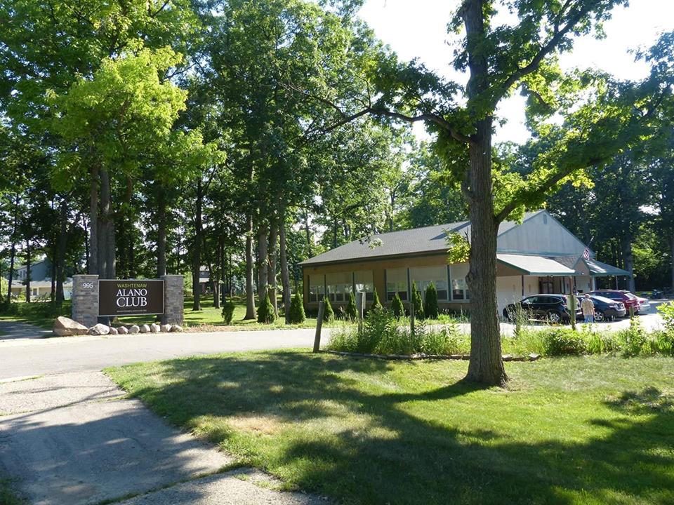
WAC now owns the building at 995 North Maple. Set on a large parcel of oak woods with picnic areas, parking, and a rain garden, its interior space consists of meeting rooms, a lounge, and a concession area. Its first major project was to build a parking lot, and a 1992 fundraising drive helped to replace the aging roof. The work of several Board committees has contributed to other improvements to both interior and exterior spaces over the years.
On May 21, 2013, as part of an effort to rebrand the Club and fulfill a strategic plan to attract more members, the Board of Directors revised Club bylaws to cancel the collection of member dues and changed the name of the Club to Maple Rock. But these efforts were not universally embraced and were challenged by some long-time members. In December of 2015, county judge Archie Brown ruled that the Club was indeed a Membership Non-Profit and, in February 2016, authorized an election to choose new Board members. The Club's name also reverted to the Washtenaw Alano Club.
Events & Activities
Over the course of its history, WAC has sponsored numerous events and fundraisers, including monthly dances held at off-site locations such as Saint Francis of Assisi Church on East Stadium Boulevard. Other annual events include picnics, Christmas tree sales, and free holiday meals. Social activities include potlucks, movie nights, games nights, and sports.
Learn More about the Washtenaw Alano Club:
Articles from the Ann Arbor News
Photographs from the Ann Arbor News
Washtenaw Alano Club's 50th Anniversary Video
Highlights from oral history interviews with Mark, Jess, Kathy, and Nan
The Many Lives of Burns Park
Olivia Hall's savvy land swap created a park, a school, and a neighborhood.
Today, Burns Park and its namesake school are surrounded by family neighborhoods. But 150 years ago, they were the back pasture of J.D. Baldwin's fruit farm.
In 1876, Baldwin sold his house on Hill St. (still standing at the corner of Washtenaw) and seventy-eight acres to Israel and Olivia Hall. The west side of the property bordered the county fairgrounds, then at the corner of Hill and Forest.
Library Threads
For nearly two centuries, volunteers and professionals have connected local readers to a wider world.
From its earliest days Ann Arbor has been a reading town with enthusiastic library supporters. Its first library was launched in 1827, just threeyears after the ci!J was founded. Even so, the history of our libraries is not a straight line from then to now. Different threads, professional and volunteer, paid and free, have woven back and forth ever since.
Today those strands are woven tightly together: we now have the professional Ann Arbor District Library and two independent volunteer groups that work closely with it. The Friends of the Library turns sixty-three this year, and the Ladies Library Association celebrates its sesquicentennial this month -- jointly with the AADL, which is marking its own twentieth year of independence (see Events, October 1).
We know about the 1827 library because in 1830, George Corselius ran an article lamenting its deficiencies. The editor of the Western Emigrant sought "twenty or thirty individuals" able to pay $3 each to expand that small collection into a more robust "circulating library." For that fee, readers could read Fanny Trollope's Domestic Manners of the Americans or the Encyclopedia Americana. Other private libraries followed, as well as reading clubs whose members bought books to share.
It wasn't until 1856 that the city had its first free, publicly accessible library. When the Union High School opened that year at the comer of State and Huron, citizens could use the library in the superintendent's office.
In 1866 the Ladies Library Association was formed as a subscription library. According to the group's history, the thirty-five founders -- "a determined group of socially prominent local women" -- paid $3 to join and $1 a year in dues for the privilege of borrowing books from its collection. They also sponsored lectures, concerts, art shows, and readings.
After renting various places, in 1885 the LLA bought a lot at 324 E. Huron. The club hired Chicago architects Allen and Irving Pond -- whose mother, Mary, was a member of the LLA -- to design the city's first freestanding library there.
Four years later, in 1889, the school board moved the high school library into its own room, and hired twenty-three-year-old typist Nellie Loving as the district's first librarian. She stayed for thirty-nine years and was an energetic advocate. "She even went to the firemen at the station," recalled Elizabeth Stack, a founder of the Friends of the Library. "They were just sitting around. 'Why don't you read something?' she asked." She followed up by bringing them books, which they later returned asking for something "livelier."
Loving's response is not on record, but the ladies of the LLA didn't just want to entertain readers-they saw themselves as "a force for intellectual and moral improvement." The minutes of the group's 1872 annual meeting observe that though the demand for fiction exceeded the supply, "we are happy to state that a large proportion of the books purchased during the year are of a character to stimulate earnest thought and fully meet the needs of the intellectual mind."
From its start, the LLA women wanted a free public library -- but they couldn't get the city to fund it. Finally, in 1902, LLA president and school board member Anna Botsford Bach suggested that the two groups apply jointly for a $20,000 grant from Andrew Carnegie, the steel magnate who was building libraries all across America. However, they deadlocked over the location: the school board insisted that the library be in or near the high school, while the LLA wanted a separate site.
The problem was solved two years later, but at a high cost: in 1904, the high school burned down. Luckily students rescued most of the 8,000 books in the middle of the night; they were stored across the street in the Methodist Church's parlor.
The school board applied for and won a new $30,000 Carnegie grant. The library was built alongside and connected to the new high school, but the school faced State St. and had a skin of brick, while the library faced Huron and was finished in stone.
In 1916, on its fiftieth anniversary, the LLA gave its collection of several thousand books to the public library, and its building to the school board. The building was used by the Red Cross in World War I, and later by the Boy Scouts. It was tom down in 1945; its site is now occupied by the fortress-like Michigan Bell building.
In 1928, Nellie Loving's successor, Frances Hannum, separated the school and public collections. She moved the schoolbooks to the third floor and made the bottom two floors a public library, with the lower level the children's room.
In 1953, the city sold the high school to the U-M, using the money to start work on what is now Pioneer High. The university renamed the old school the Frieze Building, after a beloved classics professor. When it was tom down in 2007 to make way for North Quad, the library's Huron St. face was incorporated into the wall of the quad-what preservationists call a facadectomy.
The school's move again brought up the question of where the public library belonged. The Friends of the Library was organized in 1953 to lobby for a downtown site: the comer of Fifth and William, where the old Beal house was for sale. Elizabeth Stack organized the Friends' first fundraising book sale on the grounds of the house. Friends member Bob Iglehart recalled in
The Ladies Library Association built its own "circulating library" on Huron in 1885. a 1995 remembrance that "it was a rather pitiful affair, not a whole lot of books, but there were also homemade cookies, potted plants, and the general aspect of a ladies church affair." And it raised enough money to rent a bookmobile to take books to playgrounds that summer.
The schools did buy the site, and the new library, designed by Midland modernist Alden Dow, was dedicated on October 13, 1957. Clements Library director Howard Peckham said that the shared civic space "added an extra room to each of our houses." The Friends moved their growing collection of donated books out of Stack's garage and into the library's basement, and their sales to its sheltered front porch.
The new library was still run by the school system, so the Friends lobbied for a citizens' committee to advise the school board on the library's needs. Fred Mayer, a committee member in the 1960s, recalls that they dealt with such issues as fees for nonresidents, problem patrons, new programs, and summer reading.
Finances got easier after 1973, when the school board put a separate 1.3-mill tax for the library on the ballot. It got more votes than the schools millage, and in 1974, the library added a 20,000-square foot addition. Designed by architect and book lover Don Van Curler, its high wells of windows and enclosed garden fit with the original Dow design. In 1991 Osler/ Milling designed a second addition, adding two floors to the Van Curler addition, renovating the older part, and updating mechanical systems.
In 1980 the Friends expanded their annual sales into a bookshop in the library's basement. Elizabeth Ong, who organized it, is still an active volunteer. The shop was managed for many years by volunteer Mary Parsons, who stressed in her final report that "the sales should always be considered a community service first." But in addition to getting books into the hands of new readers, the sales also raised a lot of money. The Friends used to sponsor the "Booked for Lunch" speaker series and many other services and amenities such as literacy programs, staff workshops and scholarships, and taking books to hospitals and senior residences. They also advocated for the new branches and led millage campaigns.
In 1994, when the state's Proposal A took away school boards' authority to levy taxes for public libraries, the schools and city council sponsored creation of a new district library. An interim board was created, with Mayer as president, to divide the buildings and land, and reconfigure services that had been provided by the schools.
On June 10, 1996, voters in the Ann Arbor School District overwhelmingly approved a two-mill district library tax, and elected the first library board. Of the original seven members, only Ed Surovell remains today. Twenty years later, he says, "We're dramatically better, with higher attendance and a higher number of programs." He points to advances such as more foreign language books, the incorporation of the county library for the blind, and the construction of three new branches, Malletts Creek, Pittsfield, and Traverwood, plus the expansion of the Westgate branch.
As for the Internet, Josie Parker, director of the library since 2002, says, "We decided, instead of fighting it, to use it as a tool." Parker points out that "the public can now use the library's catalogue 2417 wherever they may be." Reserving or renewing books and getting books from other libraries are also much easier. The online Summer Game attracts 7,000-9,000 players, from children to adults.
Although Ann Arbor voters have a history of supporting library funding, in 2012 they turned down a millage to build a new downtown library. Since then, the AADL has been figuring out how to best use the present building, make necessary repairs, and, in Parker's words, "match the collection with the space." Fiction has been moved to the second floor and magazines and local history materials to the third floor. The first floor still has art prints, DVDs, and new and Zoom Lends books (high-demand volumes that rent for $1 a week), along with art, science and music tools. These are stored on wheeled carts, so a large area can be cleared for special events such as the Maker Faire and a comic book convention. A library board slate running in November (seep. 35) says they'll make a new millage vote a priority.
Like the library itself, the Friends now make greater use of the Internet. In Parsons' time, when they spotted valuable books or documents, they worked at either finding a place to donate them, perhaps to the Bentley or Clements, or sold them. The Internet has made this process much easier. (It helps that many of their sorters are retired librarians or specialists who are good at identifying books of interest.)
When the elevators failed during a routine inspection in 2014, the Friends bookstore moved up to the first floor. Business was so good there that they stayed. The group now annually gives the library $100,000 or more; the money is used mostly for children's activities, including library visits for every second grader in the district. The Friends' former basement space is now the AADL's "Secret Lab," where children can work on messier projects such as cooking or art.
The Ladies Library Association also is still active. One of its earlier members, Alice Wethey, "was a terrific treasurer," says Joan Innes, a member for sixty-three years. "She was a tremendous investor and put our money into blue chip stocks." The LLA's twenty-woman board, which includes both Innes and her artist daughter, Sarah, uses the income to support the library's purchase of art books, framed fine art reproductions that patrons can borrow, and art-themed games for the children's department. As the new branches opened, the LLA also bought original works by local artists to display there.
The library has just hired its own volunteer coordinator, Shoshana Hurand, formerly with the Arts Alliance. "It's a real breakthrough and will offer volunteers a wider variety of opportunities," says library board member Margaret Leary. Parker explains that until now library volunteers have been handled by whoever answered the phone for the specific project. Now one person will see where volunteers might fit-maybe with kids' sewing or art projects, or online help, or in many other ways. The Friends will stay totally separate, although both entities will probably send people to each other.
On October 1 (see Events), the Ann Arbor District Library and the Ladies Library Association will celebrate their twentieth and !50th anniversaries, respectively. The event will feature a talk by Francis Blouin, U-M professor of history and information and retired head of the Bentley Historical Library, entitled "Connecting the City."
"We talk a lot these days about 'connectivity' that now means being plugged into the Internet and all the information it provides," Blouin explains. "But being connected certainly predates the arrival of the smartphone. Ann Arbor in the nineteenth century, though a small town, also wanted to be connected to the wider world." Thanks to generations of avid readers and hardworking library supporters, those connections now are stronger than ever.
[Caption 1]: Founded in 1866 as a subscription library, the Ladies Library Association continues to support library purchases. Artist-member Sarah Innes envisioned an early meeting (left) and painted a group portrait today (below).
[Caption 2]: A $30,000 grant from Andrew Carnegie paid for the city's first dedicated public library. Only its facade survives, on North Quad.
[Caption 3]: The Ladies Library Association built its own "circulating library" on Huron in 1885.
Birth of the Cube Farm
Driving by the deserted, dilapidated one-story building at 2285 S. State, no one would ever guess it was the birthplace of the office cubicle, an invention that radically changed the American workplace. The much-maligned "cube farm" has been the butt of untold numbers of Dilbert cartoons. But like many new products grown commonplace, the panel systems were innovative in their time, giving workers formerly stationed in rows of open desks a semiprivate space of their own.
Action Office, the original "office system," was the invention of Bob Propst, a brilliant artist and inventor hired in 1958 to create new products for west Michiganbased Herman Miller. The man who hired Propst, Dirk Jan De Pree, had already turned a small Zeeland furniture company into a major design force by being an excellent spotter of talent.
When De Pree started working as a clerk at what was then the Michigan Star Furniture Company in 1910, the company was making household furniture that replicated historic styles. In 1923 De Pree and his father-in-law, Herman Miller, took over the business. And in 1930, De Pree turned the company 180 degrees by hiring Gilbert Rohde to design modem-style furniture- a daring move to stave off bankruptcy at the start of the Great Depression. The experiment paid off when Rohde's unique designs turned out to be big sellers. "He demonstrated that mass production had the potential to spread modernism to consumers in all regions of the country," explains Phyllis Ross, Rohde's biographer. When Rohde died in 1944, DePree again looked for a star designer, and after a yearlong search, hired George Nelson. Nelson in tum recruited other talented modernists to design products for Miller, among them Charles Eames, Isamu Noguchi, and textile designer Alexander Girard.
By the time DePree hired Propst in the late 1950s, the company's star designers were segueing into other pursuits. Herman Miller kept producing modem furniture, as it still does, but De Pree was looking for new projects. Since he didn't want to offend his existing talent, he originally stipulated that Propst should "find problems outside the furniture industry and to conceive solutions for them." As it turned out, Propst didn't stay out of furniture development but instead invented the company's next major product, office furniture systems.
Propst was born in 1921 on a cattle farm. Jack Propst's right-hand man and co-holder of twenty eight patents, thinks that was where he learned to make things work: "When you live on a farm, if something goes wrong, you're the only one to fix it."
Propst's college and work life was an unusual mix of the artistic and practical. He entered college to stw.dy chemical engineering but switched to fine arts. During World War II Propst was in charge of beachhead operations in the South Pacific, which he later said taught him to innovate. When he returned from the war, he taught art, started an architectural sculpture business, and worked as a freelance inventor.
The monumental meeting of De Pree and Propst was totally accidental, according to Clark Malcolm, Herman Miller writer and researcher. De Pree had a free afternoon while visiting his son, who was teaching math at the University of Colorado. A young architect recommended he go hear a lecture by an interesting researcher. "D.J. went to hear Propst, was impressed, and sent his son Hugh to meet Propst," Malcolm explains. "Hugh did, was impressed, and began the relationship that eventually resulted in Propst moving to Ann ·Arbor to become president of the brand-new Herman Miller Research Corporation in 1960."
The official explanation for locating the company in Ann Arbor was to be close to the U-M. Malcolm suggests a more practical reason: Propst "didn't want to move to Zeeland, and he wanted to be near an international airport. He decided either Chicago or Ann Arbor would be good, opting for Ann Arbor because the drive to Zeeland in the morning would be west and back to Ann Arbor in the east. That way the sun would never be in his eyes." When these trips were necessary, Propst raced his beloved Porsche across the state.
Propst set up shop in a former .rnr,ee-loav garage on S. State. Built of poured concrete and perched on a hill, its basement was on ground level on one side, perfect for delivering prototypes of Propst's designs. Kelley, then a U-M senior studying industrial design, came to work as an intern after seeing a posting on a school bulletin board. When Kelley graduated, Propst hired him full time.
Dave Armstrong, who joined the company later, recalls that the two men worked so closely together that "Kelley could finish Propst's sentences. He was good at thinking, at making things happen." The office had only two other employeesPropst's wife, Lee Propst, who was the business manager, and Del Coates, an automotive designer, later replaced by another designer, John Holmes.
Action Office grew out of Propst's interest in trying to make offices more efficient. Its first iteration, although based on Propst's concept, was styled by George Nelson in New York (Nelson didn't want to live in Zeeland either). Introduced in 1964, Action Office I included a stand-up desk, storage unit, and accessory pieces.
"It was nice looking but too expensive and didn't work," Kelley recalls. "It was a pain in the neck to put together and not easy to work in." But though it didn't sell, it did get some good reviews, and four years later Herman Miller replaced it with Action Office II.
This time the design was completely the work of Probst and his Ann Arbor office. "It had thirteen components. It was a wonderfully simple program," recalls Kelley. The pieces included wall units, desks, storage cabinets, and file bins. A table could be brought out for meetings.
The dividing walls provided some privacy and muffled the sound of meetings and telephone calls. But the main reason for the panels was more efficient use of space. Shelves, bulletin boards, storage units, or personal items could all be hung on them without taking up desk space.
D.J. and Hugh De Pree asked Nelson and Propst to collaborate, but they never got along. When Nelson received an award for the first iteration of the Action Office, he didn't even mention Propst. When a model of the Action Office was sent to Charles Eames, in California, he sent it right back without comment.
The feelings were mutual. "Propst thought Nelson and Eames were more about aesthetics than problem solving. And they thought his stuff so ugly, who would want it?" explains Malcolm.
While Nelson and Eames thought in terms of individual pieces of furniture, Propst was interested in developing a system where the components worked together. He started by studying how people actually worked and then developed a system that facilitated productivity. "He always said, 'The solution is easy if you can define the problem,' " recalls Kelley.
Propst's concept was that the pieces could be assembled in different ways to meet each person's needs and easily adapted when their requirements changed. "People should not be planted like onions in pots to sit somewhere," he said. The thought of offices full of square cubicles horrified him. In his 1968 booklet "The Office: A Facility Based on Change," he recommended a layout of "three sides with a slightly widened opening," explaining "there is good definition of territory, privacy is well expressed and the ability to survey or participate is well maintained." Kelley admits that he was the one who unintentionally made the cube farm possible by creating a rigid connector.
Action Office II -- later known simply as Action Office -- proved to be very successful and profitable. "Propst changed the world of office design for the next forty years," says Kelley. Herman Miller added an addition onto its main building in Zeeland to manufacture the systems. In 1964 Herman Miller's sales were $10 million. By 1970 they had more than doubled to $25 million.
Other western Michigan furniture companies, such as Hayworth and Steelcase, also began producing office systems. Today most residential furniture is made in North Carolina or abroad, but western Michigan is still the world's largest producer of office furniture.
Propst's next big project, introduced in 1971, was Co/ Struc (Coherent Structures), a system for use in hospitals. Propst thought of it when he was in traction at University Hospital for back pain in the 1960s. "He watched how nurses moved around and noted inefficiencies. They noticed he took notes and told their manager, who became interested in Propst's ideas," explains Malcolm. An interchangeable system with containers, frames, carts, and wall rails to support storage cabinets and lockers, Co/Struc, like Action Office, is still in production. Kelley recently bought a storage system for his son, a dentist.
Propst's team left the old garage in 1972 for a rented building at 3970 Varsity Drive. In 1979 the company was reconfigured as the Facility Management Institute, and its mission was expanded to address more general questions of how offices could work efficiently. FMI eventually built its own building at 3971 Research Drive (now the Social Security Office). At its height, the company employed fortyfive people-architects, designers, planners, and human behaviorists-to study such subjects as how people interact in offices, optimum work environments, and training of managers.
Propst hired Dave Armstrong when he was organizing FMI in 1978. They had met when Armstrong, as associate dean of agriculture at MSU, was one of the first customers for Action Office II. Later, whenever they were in the same town, the two men would meet for dinner. Propst would always ask, 'When are you coming to work for me?'" recalls Armstrong.
"When Propst developed his theories, the modem office was just emerging and hadn't been scientifically studied by anyone," Armstrong recalls. "The white-collar boom was just starting." Today facilities management degrees are offered at universities all around the country. The International Facilities Management Association began in Ann Arbor as an outgrowth of a conference organized by Herman Miller. Armstrong was its first head.
The Propst family lived at 2347 Londonderry in a house designed by·modem architect David Osler. Kelley remembers that the house was filled with "stuff he designed, sitting on classic pedestal columns. He was always moving around, so the sculpture was always shaking." Kelley describes Propst as "really down-to-earth. There was nothing pretentious about him. He knew he was smart, but thought life was to be lived."
Propst left Herman Miller in 1980. There were differences of opinion, especially over the way Action Office was being used, and a new president coming in. Armstrong took over FMI.
Clark Malcolm joined the office in 1983, so he never worked under Propst. However, he had seen him a few times when he was working at the Centicore bookstore near campus -- "an odd guy who came in to buy art books around Christmas for his employees. he would spend a couple thousand. He was tall, bald headed, stocky, and crotchety." Propst eventually moved to Seattle, where he pursued new design interests, including modular homes, until his death in 2000.
The State St. building served as the retail outlet for Ann Arbor Plastics, then was occupied by a series of food-related businesses. Ali Hijazi opened La Zamaan Cafe there in 2007, but stayed only a few months before deciding "it was not suitable for sit-down customers." Several other eateries have come and gone since. At present it stands empty.
Armstrong left FMI in 1986, when Herman Miller reconfigured the company as Metaform. A reduced staff of about ten studied products that could help older people stay in their own homes longer. When Metaform closed five years later, the remaining staffers transferred to Zeeland, except for Malcolm. Working out of an upstairs office in his house, he wrote five books with D.J. De Pree's son Max and wrote or co-authored more than ten more about facility management, architecture, and design.
The fiftieth anniversary of Action Office this year has renewed interest in Propst's work-in May, he was written up in both the Wall Street Journal and the New Yorker. Though never as famous as some of Herman Miller's other designers, his designs touched more people's lives, for better or worse. Asked about the long-term effect of Propst's work, Malcolm answers, "Bob Propst and his invention completely changed the way we think about knowledge work and the places it happens."
From diagram (print edition): Three sides with a slightly widened opening appears to be the best enclosure of all as a generality. There is good definition of territory, privacy is well expressed and the ability to survey or participate is well maintained.
Four sided enclosure is bad for the wide awake and activity-oriented man. He is isolated, insulated, and remote. His ability to be part of an organization family is diminished. Bad Cubicle!
Propst saw his invention as a way to customize spaces to meet people's needs -- the thought of offices full of square cubicles horrified him. His right-hand man, Jack Kelley, admits that he was the one who unintentionally made the cube farm possible by creating a rigid connector.
Photographs (in print edition): (Top) Bob Propst (right) with fellow designer George Nelson. Though they collaborated on Herman Miller's first office system, Action Office I, they never got along. "Propst thought Nelson and [Charles] Eames were more about esthetics than problem solving," says Miller writer and researcher Clark Malcolm. "And they thought his stuff was so ugly, who would want it?" The far more successful Action Office II (below left and right) was entirely designed at Propst's Ann Arbor office.
See also the following video, in which author Grace Shackman talks with Bob Propst, former president of the Herman Miller research Corporation. He designed the Action Office furniture system, which reshaped the American office by providing a semi-private space to work in.
https://www.youtube.com/watch?v=89rsc660kFg#t=558
Saline's mansion
A May fund-raiser offers a once-in-a-lifetime chance to see how the Davenports and Curtisses lived
The Davenport-Curtiss mansion and its grounds take up a full block of land right on Michigan Avenue in downtown Saline. The house is so impressive that someone I know assumed it must be a public building—only when he was rebuffed at the door did he learn to his embarrassment that it is a private residence. Built in 1876, the mansion has served as a home for two presidents of the Citizens Bank of Saline, William Davenport and Carl Curtiss, and is still owned by the Curtiss family.
Davenport (1826-1909), the bank's founder, built the house, hiring prominent Detroit architect William Scott to design it. (Scott, trained in England, also designed the 1882 Ann Arbor fire station—now the Hands-On Museum.) The Curtiss family still has the blueprints, which are written on linen and include the instruction that "only finest materials available will be used."
Scott designed the house in the Second Empire style (named for the reign of the French emperor Napoleon III), with a tower and a mansard roof. It was one of the first homes in the city with indoor plumbing. Quality wood—walnut, maple, tulipwood, and butternut—was used throughout, and Davenport furnished the house with pieces purchased at the Philadelphia Centennial Exposition, an international trade fair held the year it was built. Outside he built a matching carriage house and stable, and he landscaped the grounds with rare trees.
Davenport had earned his fortune as the owner of Saline's largest general store, which segued into a bank. His father died young, and Davenport began working when he was twelve, starting as a clerk in Caleb Van Husen's store in Saline. He was just twenty-five when he opened his own store in partnership with H. J. Miller, whom he bought out two years later. The business thrived, selling everything from sewing supplies to food to wool, and in 1863 Davenport built a new three-story store on the northwest corner of Michigan Avenue and Ann Arbor Street.
Since Saline's only safe was at the new store, people often asked Davenport to store their cash and other valuables. As the town thrived, especially after the arrival of the train in 1870, Davenport's financial transactions increased. In 1885 he formally organized the bank, which he initially operated out of a comer of his store. Davenport and his wife, Zilpha, were civic leaders. She helped organize the Saline library. He organized the volunteer fire brigade and donated much of its equipment, personally traveling to New York to purchase a hand-pumped fire engine that drew water from cisterns dug under the streets. Davenport "has been prominently identified with all Christian, moral and benevolent movements," a local historian wrote effusively in Charles Chapman's 1881 county history, "and is well noted for his kindness and generosity."
Davenport's son Beveriy (1852-1930) graduated from Detroit Commercial College and succeeded him as bank president after his death in 1909. In 1917, Beverly Davenport remodeled the bank's interior, hiring a New York architect who specialized in financial institutions.
Beverly Davenport died without an heir (his only son, Edward, predeceased him). But luckily there was an employee, Carl Curtiss, who was more than capable of taking over. Curtiss was born in 1883 in Camden, a small town southwest of Hillsdale; he started working at the bank as a teller in 1908, shortly after graduating from Hillsdale College. When William Davenport died, Curtiss was promoted first to assistant cashier and then to secretary of the board and cashier—the posts formerly held by Beverly Davenport. After Beverly's death, Curtiss succeeded him as president of the bank and inherited the Davenport mansion.
When Curtiss moved in, the house had been unoccupied for quite a while and still contained all of its original furnishings. (Beverly had had his own house on Henry Street, just behind his father's.) Curtiss admitted in a 1952 Ann Arbor News interview that he had been tempted to tear the mansion down when he first glimpsed the interior. It was over fifty years old by then, and the plaster was cracked, the fixtures old, and the rooms drab and dirty.
Curtiss's friend Henry Ford convinced him that the house was worth saving, and sent experts from Greenfield Village to help him figure out how to restore the building and furnishings. Curtiss didn't take all of Ford's advice, however—for example, he refused to keep the walnut bathtubs with their copper linings, preferring the convenience of a modem bathroom.
Ford also sent over some of his men to plow up the yard for gardens. In the Curtiss era the house became known for its rows of peonies, hundreds of rose bushes, and thousands of tulips. Curtiss's granddaughter, Mary Curtiss Richards, remembers that the gardeners used to dig up the tulip bulbs every year and dry them on screens for replanting.
While meticulously restoring his house, Curtiss was also earning the respect and gratitude of the community by the way he was running the bank. Though he took over at the beginning of the Great Depression, he dealt with people in a humane way, which also turned out to be good for Saline's future economy. Mary Richards tells how he survived the 1933 bank "holiday," when a panicked run on assets caused many banks to close. "He stood on the steps of the bank, cash in hand, and handed it out," says Richards. "After a few [depositors got their money], they stopped asking to take it out and started putting it back." Some area farmers remember to this day that Curtiss lent them money when their crops failed, and according to Richards, he never foreclosed on any property.
After World War II, loans from Curtiss helped start new businesses, most notably Universal Die Casting, which became Johnson Controls. Curtiss also continued the Davenport tradition of civic involvement. He served on the city council and school board and, during World War II, on the draft board. He donated to countless local projects, including the Saline Community Hospital and the Saline Methodist Church. He paid for high school band uniforms and for much of the land for Curtiss Park. He was a charter member of the Saline Rotary Club.
Curtiss and his wife, Vera, participated in the social life one would expect from a big banker. Richards remembers that they were regular attendees at the musical May Festival in Ann Arbor. "Grandma would get a new dress and dress to the nines," she recalls. "Sometimes she'd get a new piece of jewelry for that, too."
Asked whether it was hard being the granddaughter of the big banker in town, Richards laughs and says, "No, not at all. We were proud of him. We never heard anything bad about him."
Curtiss served on the National Bank Board, and when he went into Detroit for meetings, he and Vera would often take in a play afterward. They sometimes entertained in their house, often in connection with some philanthropic project. Being strict Methodists, they didn't serve anything stronger than ginger ale.
At the time, Richards lived with her parents, Bliss and Vera (her mother had the same name as her grandmother), and her brother Carl in a house her grandparents had built when they first came to Saline. But Richards says she was invited to the Davenport-Curtiss mansion "all the time." Most of her memories of the house are of family events, such as watching movies in the basement (Curtiss had his own projection room, and Richards's family still has some of his movies), or eating her grandmother's waffles on the maid's night out.
Curtiss never retired from the bank; he continued working until his death in 1967 at age eighty-four (Vera had died ten years earlier). In 1964, he oversaw the replacement of William Davenport's original bank building with a new Citizens Bank facility. While in the hospital for his last illness, he was worried that he would spoil his perfect Rotary attendance, so his fellow Rotarians offered to meet in his hospital room. He. died before the time of meeting, leaving his record intact.
Richards's parents moved into the mansion after Carl Curtiss died. A few months later she married, and her parents hosted the reception on the grounds. "It was the last big event [held there]. There was a band, a tent. They went the whole nine yards," says Richards. Her mother kept the house immaculately clean, and even though they regularly hired cleaning help, she insisted on cleaning the Czechoslovakian crystal chandelier herself, still climbing on a stool to do it until she was well into her nineties.
Bliss and Vera Curtiss opened the house to one homes tour in the 1970s. But since then the family has maintained strict privacy, except for letting Saline fourth-grade teacher Audrey Barkel bring students through on tours. "It's a once-in-a-lifetime experience for those kids to be in there," says Barkel, who has been taking kids through for about twenty-four years.
This spring Bliss and Vera's son Carl, with his sister Mary's help, will open the house to the public again for a very special event: a garden party to benefit Arbor Hospice, which took care of Vera so that she was able to die at home in 1998 (Bliss had died in 1977). The fund-raiser will be held May 21 from 1 to 4 p.m. Docents will explain the history of the home and garden, and refreshments and a booklet about the house will be available. Tickets, limited to 250, will cost $50, and will be available at Arbor Hospice and various Saline merchants, including the Calico Cat. For more information, see Events, p. 53.
—Grace Shackman
A Piece of Henry Ford's Dream
Phoenix Packaging has revamped his one-room Saline schoolhouse.
Henry Ford knew how to run a car company, and he thought he knew how to run the country. In his view, the rural values of his childhood, including education in a one-room schoolhouse, represented America at its best.
In 1935 Ford turned Saline's Schuyler Mill, on Michigan Avenue, into a soybean processing plant. Soon after, he moved a dilapidated old school from Macon Road to a site directly across the street. He intended it for the children of the men who were producing plastics and paints at the restored mill (today Wellers' banquet facility).
Ford spared no expense to restore the school, complete with cloakroom, potbellied stove, and two-person desks. He even installed two outhouses (modernized with real plumbing and heating). On September 7, 1943, Ford attended the opening of the school.
Many of the thirty-five students, who ranged from kindergarten through eighth grade, had tenuous connections to Ford, or none at all. Allen Rentschler's father was farmer, although his uncle, Carl Bredernitz, worked at the soybean factory. Bob Cook's father was a Chevrolet dealer. Thelma Wahl Stremler's dad worked at Bridgewater Lumber.
Like the physical structure, school ac- tivities were a mix of modern and old-fashioned. "We had the latest books, the latest teaching methods," recalls Cook. The older children often served as teacher aides. "I helped the younger ones read, but I felt I was just having fun," remembers Stremler.
Each day started with a chapel service that included recitations by students and hymns led by Stremler on the piano. At recess children of all ages joined in games such as kickball and softball. Ford furnished the school with looms of various sizes.
For students and parents, one attraction of the school was free medical and dental care. Both Rentschler and Stremler got their first eyeglasses thanks to Ford.
The Saline school was one of several Ford built near his small plants. Don Currie, the first teacher, moved on after a year to become principal of Ford High School in Macon. Clare Collins, later a shop teacher at Saline High School, took over from Currie.
The one-room school didn't last long. In 1946, Ford, in failing health, decreed that all his schools would close at the end of the semester. The students returned to public schools; they had little trouble adjusting. Ford died a year later at age eighty-three.
The Saline public schools were not interested in the building, so it was sold to Elizabeth and Bruce Parsons. The Parsonses moved the entrance to the side, added a two-story wing with four bedrooms, and divided the schoolroom into a kitchen, dining room, and living room.
By 2002, when Patricia and Chris Molloy bought the building, a series of owners had let it deteriorate. The Molloys wanted to turn it into an office for their company, Phoenix Packaging. After some negotiations with the city, the Molloys agreed on a historic-preservation easement in exchange for business zoning. In the future, the exteriors of the buildings may not be altered without the city's permission.
The Molloys carefully preserved and restored what was left of the original school, including the hardwood doors, floors, and wainscoting. The first floor is their office; they rent the upstairs to attorney Russell Brown and a separate shed to architect Dan Kohler.
The Molloys have a collection of Ford School pictures on the wall. They acquired an old potbellied stove but then learned that the Saline Area Historical Society has the school's actual stove. The Molloys have agreed to a swap. Now they are keeping their eyes out for one of the old two-seater desks.
—Grace Shackman
Building Bookshelves
Citizen passion helps libraries grow. In 1909 the women of Manchester defied their township government and started their own library. In other Washtenaw County towns, women also led volunteer efforts to build and stock local libraries. Long before the era of library boards and dedicated millages, these places became cherished sources of community pride. For more than a century, local libraries have exemplified the character of the towns they serve. To get them started or keep them going, citizens painted walls, built bookcases, and raised money with card tournaments, puppet shows, and other events. When libraries relocated to larger quarters, members of service groups, from Boy Scouts to Kiwanis clubs, moved the books. Townspeople also defended their libraries' independence. In the 1930s, Frances Hannum, head of the Ann Arbor library, tried to organize a countywide system but got a cool reception. In the 1960s, when the Washtenaw County Library was established to serve unmet needs, there was again talk of a combined system. But communities preferred to keep their own libraries, even if it meant staying in cramped quarters. Today, financed by property taxes and run by professionals, local libraries offer materials and services never dreamed of in the era of volunteers. With larger and more modern facilities, the challenge is to give residents access to global resources while preserving tradition and a hometown feel. In the nineteenth century, readers in western Washtenaw made do with tiny libraries in township halls, schools, or churches. Often these consisted of a single shelf of books. Some local merchants kept lending libraries, from which customers could borrow books for small fees. A drugstore in Dexter had one; so did a Chelsea jewelry store, which carried mostly western novels. As the twentieth century dawned, women started organizing real town libraries. They found space, collected books, ad raised money, often with the help of a benefactor, usually the wife of a prominent local businessman. That's what happened in Saline in 1900, when a group of civic-minded women formed the Saline Library Association, and the community rallied to help them. The village council provided space in its chambers, the Methodist church provided bookcases, and people donated books. The organizers raised money through lectures and lantern slide shows to operate the library, which originally was open only on Friday afternoons. By 1907 the Saline library had outgrown the council chambers, and Zilpha Davenport, wife of William Davenport, founder of the Citizens Bank, convinced her husband to house the library in a little building in back of the bank. In 1917, when the bank needed that space, the Davenports paid for construction of a new library at 105 North Ann Arbor Street (now the Drowsy Parrot). Ken Heininger, who grew up in Saline, recalls that it looked like "an English manor library," with tall bookshelves all the way up to high ceilings. Max Collins remembers the sliding ladder used to reach the higher shelves; he also remembers the mezzanine, where as a young child he would play while his grandmother did her volunteer stint. Neither Heininger nor Collins remembers ever taking out a book. "I don't think they had children's books," says Collins. As a high school student in the 1940s, Wayne Clements used the library, but he didn't find it a very welcoming place. The strict librarian monitored all activity from her desk in the middle of the room. "She ran a tight ship," Clements recalls. "There was no fooling around. You got the book and left." He doesn't remember there being any tables to sit at. The Saline library remained in the building until 1967. Manchester's library got an early start: organized in 1838, it was the state's first township-run library. It originally consisted of a row of books on a table in the township office. The township clerk received an extra $25 a year for serving as librarian during its hours of operation, 2 to 4 p.m. on Saturdays. Early in the twentieth century, the women of the community stepped in. According to a 1926 history written by then-librarian Florence Case, the books in the old library were deteriorating. In 1909 Manchester had four women's study clubs—the Shakespeare Club and the Twentieth Century Club (both of which still exist), the Academy of Forty, and the Saturday Club. Evelyn Spaford, president of the Saturday Club, called a meeting of these groups to form a library association. "They braved the silent disapproval of the township board and installed the library in a room of its own in the Conklin building," an anonymous historian wrote in the library's archives. The women went to work building shelves, gathering books, and raising money. In 1923 the library moved to upstairs quarters in the Mahrle Building on Adrian Street, opening to the public one evening a week. The late Glenn Lehr recalled in a 1998 interview that the library was in a long, narrow, fairly dark room heated by a potbellied stove. By the time he was fourteen, Lehr said, he had read every book in the collection. Women also launched the first libraries in Dexter and Chelsea. Dexter's opened in 1927, under the sponsorship of the Dexter Woman's Study Club. Club member Cornelia Copeland's brother, U.S. senator Royal Copeland, let them use a little building he had restored. He kept an office in the back to use when he was in town. Now housing the Cookie MOMster, the building, a former post office, had once been owned by village founder Samuel Dexter. At Senator Copeland's request, the library was named the Alice Frances House, after his mother. It was open mainly on weekends. The librarian, Flora Smith, wrote local history articles for the Dexter Leader and lived across the street in a yellow brick house, since torn down. Libby Davenport recalls that she and her sister Doris used to go to the library on Saturday afternoons after having cones at Connor's ice cream shop. "We had to show our hands when we came in to the library," she says. "No sticky hands were allowed." Chelsea's library started as a project of the Child Study Club (now the Woman's Club) in 1932, a few weeks after a speaker from the Michigan Child Study Association gave a talk on libraries. Winifred Palmer, wife of a local doctor, chaired the effort. A store donated a room, and club members dyed sheets maroon to hang as dividers. They painted donated bookcases and tables the same color and opened with twenty-two of their own books and 100 more on loan from the state library. Open three hours twice a week, the library was staffed by pairs of volunteers from the club. Its backers raised money from bake sales, card tournaments, and puppet shows. They also held "give-a-book weeks" to encourage donations. In the next two decades the library moved several times to various rented quarters. Manchester was the first of the four towns to have a dedicated library building. In 1934 library organizers bought the Lynch House at 202 West Main Street on the village square. The monthly payments to buy the house were lower than the rent for the room in the Mahrle Building. Once again, the move was a community-wide effort. Local churches put on a benefit play, and volunteers cleaned, painted, and built shelves. The Boy Scouts moved the books. At first the entire collection fit in the home's living room. The upstairs was converted to an apartment for the librarian, Jane Palmer, who planted flowers in the front (some of those plantings remain). Unlike Manchester's library, which had a history of township funding, the libraries in Saline, Chelsea, and Dexter ran entirely on voluntary contributions. During the Great Depression, though, gifts dwindled and citizens wanted government funding. In 1938, when Senator Copeland died and bequeathed the library building to Dexter, the village agreed to take over financial support. Saline's city government allocated some tax money for the library. In 1940 Chelsea villagers taxed themselves a half mill to support their library, raising the rate the next year to one mill, the legal limit at the time. The libraries also began to receive state aid, mainly from court fees, and sometimes surrounding townships made nominal contributions. By the 1950s the Chelsea library was looking for more space. Gertrude Daniels, wife of the owner of Chelsea Lumber and a library backer, asked Catherine McKune whether she would will her house to the library. Since 1870, McKune's family had lived at 221 South Main, in a house built in 1860 by Elisha Congdon, who with his brother James had founded Chelsea. McKune agreed, and upon her death in 1958 the library acquired the building. "There was a lot of overlooked maintenance," remembers Katherine Wagner, Catherine McKune's niece, but the citizens of Chelsea were up to the task. Wagner's bridge club painted the front room; it became the children's area. A caretaker lived in a small apartment upstairs, and another room was furnished by the Woman's Club for its meeting place. Eventually the library expanded to fill the entire house. In 1963 the Dexter library bought a house at 3173 Baker Road with voluntary contributions from surrounding townships. Katie McKillen ran the library for more than thirty years. "It was said that she knew every book and if it wasn't in, knew who had it out and when it was due back," says longtime board member Marti Davis. In 1967 the Saline library, having outgrown its 1917 building, moved to 201 South Ann Arbor Street. The building had been built as a church in 1904 and later was used as a private residence, a furniture store, and a hospital. State legislation passed in 1989 allowed two or more units of government, including a school district, to form a library. The new law was very timely. The libraries in Chelsea, Dexter, and Saline had built additions onto their converted buildings, but all three, as well as Manchester's library, were outgrowing their spaces. They needed bigger tax bases to finance their moves to new buildings. Saline was the first to take advantage of the law. In 1991 the city and school district asked for a joint millage—0.9 mills for operating expenses and 2.2 mills for a new building. Local architect Michael Pogliano designed a modern glass-filled, open-roomed library, at 555 North Maple Road; it was organized by Leslee Niethammer, the first Saline librarian to have a master's degree in library science. Niethammer also worked with the U-M School of Natural Resources and the Saline Eagle Scouts to create a woodland trail on eleven acres surrounding the library. In 1994 voters in the Dexter school district approved a half-mill levy for library services. The library hired its first master's-degreed librarian, Paul McCann. Using proceeds from the sales of its Baker Road house, the board bought the former Methodist Church Education Building at 8040 Fourth. With more space and a larger budget, McCann expanded the library's holdings and programming. Circulation rose from about 20,000 books a year in the old building to 20,000 books a month today. Dexter now has the smallest building and the smallest millage of the four western Washtenaw libraries, but it's very busy. McCann says, "You would be hard pressed to find a library with our circulation with our budget." Chelsea organized its district library in 1997. In 1999 voters in the school district approved 1.75 mills to run a larger library but rejected a building millage. "They turned it down because there were too many uncertainties," says librarian Metta Lansdale. Most folks wanted the library to stay in McKune House, but the library needed space for parking and expansion. Getting it proved complicated. First, Gloria and George Mitchell agreed to relocate their business, the Staffan-Mitchell Funeral Home, which was across the street from the library. That building was then torn down for a parking lot. Next, a house on Orchard Street was moved so that Frank and Kathryn Staffan could move their house, directly behind the library, onto the Orchard Street lot, giving the library room to expand to the rear. While this was all being negotiated, the library had to leave the McKune House because it was not handicapped accessible. It relocated to the media center at the old high school on Washington Street. Biding her time, Lansdale used the operating money to prepare for a bigger library, adding books, training new staff, buying more computers, and organizing programming. In May 2004 voters agreed on a millage that will provide $8.2 million to build an addition behind the McKune House. Ground was broken April 17, and the library plans to move by September 2006. Manchester was the last of the four towns to form a library district, in 2000. Its service area includes portions of the school district in Manchester, Freedom, and Bridgewater townships. The old library was centrally located but very crowded—every time it bought a new book, it had to get rid of an old one. The former home also was not handicapped accessible. So when Manchester's village government acquired the old Ford factory on the east side of town in 2000, it agreed to rent space to the library. A 1941 Art Moderne building overlooking the Raisin River, it was originally one of Henry Ford's mills. The library has large windows with light pouring in and beautiful river views. Voters recently renewed the millage for another ten years, and Freedom Township, which was considering leaving the district, voted to stay. Many residents of each town had mixed feelings about trading in their cozy small-town quarters for more modern facilities. "It's louder, busier - there's more energy, more milling about," says McCann, the Dexter librarian. The four librarians try to keep things personal; all have their desks near the fronts of their libraries. And all offer full schedules of programs. The libraries share resources and information. Heather Sturm, who started as Manchester librarian this year, uses a planning consultant suggested by the other librarians and a survey form created by Paul McCann. The Washtenaw County Library serves the blind and handicapped of all the districts, and county librarian Mary Udoji holds seminars to acquaint area librarians with county services. Manchester, Dexter, and Chelsea belong to a library co-op that allows them to borrow from about seventy libraries in southeastern Michigan. Patrons usually have to wait only a few days for the materials they request to be delivered. A feeling of community ownership remains a key ingredient in the libraries' successes. In 2002, Dexter voters turned down a millage to build a new library on Parker Road because it was too far from town; the board is now suggesting building downtown behind the fire station. In Manchester there is no room to expand. "We may someday need to move to bigger quarters, but I'm not worrying about it now," says Sturm. Saline already is outgrowing its building and will probably go to the voters for an expansion millage in 2006. Growth and change continue, but every library is striving to maintain a strong tie to its community and its long history. Photo Captions: When Saline's Drowsy Parrot was the town library, Max Collins used to play on the mezzanine while his grandmother volunteered. After making do with rented or donated quarters in other buildings, libraries found their own homes: the McKune House in Chelsea, the Lynch House in Manchester, and in Saline (center) a library constructed in 1917 (now the Drowsy Parrot). Dexter's Paul McCann and Saline's Leslee Niethammer are the first master's-degreed librarians to serve their towns.
Housing the Homeless
How Avalon Housing helps people out of the shelter and onto the road to a normal life.
In English legend, Avalon is the island paradise to which King Arthur was borne after his death. In Ann Arbor, Avalon is something almost equally miraculous: a non-profit organization that in just five years has developed eighty-one rooms and apartments for low-income people, most of whom were previously homeless.
Avalon Housing's hundred-plus residents may not think they are in heaven, but they are certainly much happier than they were on the streets or in temporary shelters. They are free to develop their skills, pursue career interests, and lead more normal lives. Because of Avalon, Larry Morris has time to read the Constitution and the Book of Mormon, Ron Yarrington to entertain friends in his home, "Sandra" to write and go back to school, and Ron Brumbaugh to play his guitar and go swimming at the Y.
Morris, forty, dressed in maroon sweats, sits on the front steps of an Avalon house on South Division and recalls his troubles over more than a decade in Ann Arbor. "I came from Detroit in 1984 to go to school, Washtenaw Community College to study liberal arts, but ended up at Ypsi State with schizophrenia. I had the symptoms before, but they were unidentified. When I got out I worked at restaurant jobs—Wendy's, Kroger's. I would lose apartments because of code violations. In between [apartments], I was in and out of the shelter."
Morris heard about Avalon at Full Circle, an Ypsilanti clubhouse for mental health consumers. He signed up, and after a year's wait, moved into his new apartment. With a place to live, Morris began to work, first as a volunteer at the VA Hospital, then in a paid job in the hospital's mail room as part of a transitional employment (TE) program sponsored by Trailblazers, the Ann Arbor clubhouse. He plans to work in several more TE placements and then hopes to return to college.
Like Morris, many Avalon residents have never before had permanent housing. Yet his is just one of Avalon's many success stories. The group's achievement is even more remarkable considering that Avalon is housing a population that has baffled housing experts around the county.
Avalon, which started as an offshoot of the Homeless Shelter of Washtenaw County, now houses people at eleven sites around Ann Arbor. Its staff of six works out of a three-room office at 404 West Washington, in front of the Performance Network. It is filled with odds and ends of furniture, bright posters, ringing telephones, and a hubbub of activity. The day I visit, tenant Ron Brumbaugh drops in and excitedly tells site manager Maggie Camacho that he has a new job doing maintenance at the Y. Camacho, formerly of Ozone House, is the staff member who works most directly with Avalon tenants, and her popularity, with a group accustomed to seeing landlords as the enemy, is legendary.
In the next room, Michael Appel, formerly of the U-M housing reform project and a member of the original Avalon board, arranges the complicated funding for future projects. His zeal prompts fellow staffers to ask him to slow down so that he won't acquire new property faster than they can manage it.
Executive director Carol McCabe leads me into her office in the back in a futile attempt to find a quiet spot. McCabe directed Avalon as part of the shelter until they separated. Her conversation is filled with words like "challenge" and "struggle," but there are rewards, too, in seeing the improvements Avalon can make in the lives of its tenants.
McCabe organized Avalon with the backing and advice of former shelter director Jean Summerfield. Summerfield, who now works in Chicago, says, "The best thing I did when I was in Ann Arbor was letting Carol do Avalon."
Avalon was born in 1991 when the city offered to give away a house on William Street that was in the path of a proposed parking structure behind Kline's. The house, occupied by squatters, had become a focal point for housing activists. "The town was talking about housing, but no one stepped in," McCabe recalls. "[Summerfield] was willing to move the shelter that way."
"We got into it because nobody was doing housing development for these folks," Summerfield recalls. "Nationally, most of the low-income, special needs housing did a lot of screening out. We wanted to focus on screening in."
The shelter had experimented with transitional housing and group homes, but the temporary nature of the former and the lack of staff oversight of the latter prevented either option from becoming a permanent solution. McCabe, at the time director of WIT House, the shelter's transitional home for women, saw firsthand the need for permanent low-income housing. Without it, "the women could get sober, could get their kids back, could get the right medication, could leave an abusive relationship—and still have no place to go."
The problem of finding rooms and apartments affordable for people with minimum-wage jobs or on public assistance was nothing new to shelter employees. And even when a place was found for them, shelter residents often weren't together enough to live on their own; like Morris, they kept coming back. "Some ran through every landlord in town," says McCabe.
While the Kline's lot house was being moved to 201 West William and rehabbed, Avalon's founding group worked on strategy. Says McCabe, "There had not been a lot of managing. We felt, because of the target population, this was the reason most hadn't been successful in rental housing. We developed 'enhanced management,' where we put human needs first. We use eviction only as a last resort."
Avalon's founders wanted to make mental health and other support services available to its residents. But, McCabe stresses, "we're not a residential [treatment] program, but permanent housing." Those Avalon tenants who need help with day-to-day problems beyond what their mental health case workers are able to provide can get it through CHIL, the Cooperative Housing and Independent Living Initiative. Staffed by Synod Residential Services and funded by Washtenaw County Community Mental Health (CMH), CHIL is part of an ongoing effort to treat CMH clients in the least restrictive setting—in this case, by allowing clients who would once have been housed in group homes a wider choice of housing.
Avalon works to avoid evicting clients by negotiating individual contracts with them beforehand to anticipate known problems. With mental health consumers, CHIL and the caseworkers are also involved. Most tenants are on month-to-month leases, which gives Avalon leverage in enforcing the contracts. Avalon staffers meet weekly with tenants' caseworkers and CHIL.
A condition of some of the leases is that the tenant must accept the help of a "representative payee," a person authorized to help manage their money, paying bills for them or doling out the money in small amounts, and teaching them money management. Says McCabe, "We negotiate this before they move in or if they bounce checks regularly." The representative payee helps people who have enough income to afford a room but can't keep their money long enough to pay rent.
Some of the returning shelter guests had been ousted from past apartments because of housekeeping problems (including spoiling, uncovered food), fire hazard-level hoarding, and plumbing problems. At Avalon, McCabe says, plumbing problems have included "putting food down the toilet and overflowing the bathtub or sink. Many wash a lot; one woman dyes her hair every day."
Avalon inspects regularly, both formally and informally, to catch hygiene problems before they get out of hand. CHIL helps by organizing cleanup days and educating tenants, while caseworkers refer people to clinics and work to get them on the best medications.
Another problem, according to McCabe, is that many of the Avalon tenants are fine on their own, but vulnerable to exploitation. "They'll bring in whole families or drug-using buddies or put up with abusive boyfriends."
One tenant was in danger of being evicted because her drug-using ex-husband would come and make a fuss at her place late at night. Finally, after nine months of discussion, she was persuaded by CHIL to let Legal Aid obtain a restraining order against him. In another case, a person on probation was bothering an Avalon tenant. McCabe went to the probation department and managed to have the person barred from Avalon property.
Drug users account for most of Avalon's failures. Working closely with CHIL, they have persuaded some tenants to go into treatment or into more structured settings. In half a dozen cases, however, Avalon has evicted tenants, McCabe says, "when we couldn't work anything out" to resolve substance abuse by tenants or their friends.
Tenant Mary Beth Matthews witnessed one such case. "There were three crack heads in the house. They had guys in their room. Avalon got them out, slowly, giving them every chance to mend their ways."
"We've learned our limitations," says McCabe. "We're currently screening out 'dually diagnosed'—people with both mental illness and chemical dependency. They're the hardest to treat; there are very few treatment alternatives." Avalon also refuses to house people known to be violent. But unwilling to completely admit failure, McCabe says, "We would always consider rehousing people, other than those with major violence, if they came back after x number of months of being clean."
Just as Avalon has been learning as it goes how to deal with the problems of its target population, the group also has been discovering what kinds of housing work best. After finishing the William Street house in the fall of 1992, they purchased two older houses on North Main (532 and 618), one of them previously run by the shelter. Both were suitable for single room occupancy (SRO), with private bedrooms and shared bathrooms and kitchens. Next they bought three houses of the same vintage on South Division (518, 520, 522), setting a pattern they would follow with future purchases: involving the city and the county, both of which have given direct grants, in-kind assistance, and help in finding other sources of revenue—HUD through the city and human services through the county.
Avalon concentrated on SRO's initially because they were the cheapest units. But they soon discovered that people preferred the privacy of an apartment. There were also fewer interpersonal problems when tenants didn't have to share bathrooms and kitchens. So when a fourteen-unit apartment complex at 211 Davis came onto the market, Avalon bought it. Next was an apartment complex on Stimson, near South Industrial, which had larger apartments suitable for families. The most recent purchases are a house at 610 West Summit with six apartments, and two duplexes on Allen Street for single mothers, a joint endeavor with Safe House.
None of these projects proceeds until funding is arranged that allows rents affordable to the people Avalon is trying to serve. Most of its tenants have incomes of around $450 a month. SSI (Social Security benefits for people on disability) is about $450 a month; a single mother with one child gets $401 from AFDC; while minimum-wage jobs bring in about $680. Avalon rents range from $204 for an SRO room to $375 for a two-bedroom apartment. To keep its units affordable, McCabe explains, "we do the opposite of for-profit groups. They decide on rent based on their costs. We decide on the highest rent we can charge and still make the project worth doing and then work backward." To get money to fill the gaps, they appeal to multiple agencies, private and public, for grants and low-interest loans. At the opening ceremonies for the Stimson Street property last spring, there were seven speakers, all representing agencies that had loaned or given money for the project.
When a project is being considered, McCabe visits with a delegation. Among the people she calls on are Larry Friedman and Glen Ziegler of the city's community development department; Mark Robey from CMH; Realtor Doug Smith; and Terry Alexander, an architect who volunteers as an advisor on project feasibility. Because of all the groups involved and all the steps needed, the projects often take a long time to complete; but once they have been decided on, Avalon sticks with them until they work out.
Despite the slow process, McCabe has found an increasing willingness among sellers to work with Avalon. Some come back with a second offering after selling them one project. "They're calling us more," says McCabe. "They know we always get our reports in on time, that they are accurate. We have earned their respect."
Once Avalon acquires a property, they rehab it to the highest level they can afford, often doing "twenty years of deferred maintenance," says McCabe. "We never will sell the properties, so we do as much as we can at first. We get a lot of scrutiny from neighbors. We improve the physical structure and grounds. We spend more than a landlord who will sell in a few years."
McCabe thinks this investment may be one reason Avalon has experienced so little opposition. "Neighbors are often our best supporters. They see the same tenants, but with more maintenance. They've offered to talk to new neighborhoods. When an unwanted friend broke a window [at one of the houses], the neighbors helped board it up." Avalon gives neighbors a twenty-four-hour beeper number and encourages them to call with any problems.
Bob Barackman is another reason the neighbors are so cooperative. As Avalon's director of maintenance and rehab, Barackman works hard to create good relations, doing things like shoveling neighbors' walks when doing an Avalon property. A retired Wayne County sheriff's deputy, Barackman finds the people skills he learned in nineteen years as a cop are handy in Avalon.
Gruff and sometimes inclined to tease the idealistic young Avalon staff, Barackman is as concerned about the residents as anyone. "I enjoy the job," he says. "It's not just the ordinary landlord-tenant relationship. Whatever the problem, we'll solve it. We juggle people around when we have tenants who don't get on."
On a warm fall day, Barackman drives me around in his truck, showing me the Avalon properties. At the home of "Susan," the woman who finally had the restraining order placed on her ex-husband, he becomes worried when she doesn't answer his knock. "She's truly a victim, but we've seen her turn around," he explains. "She divorced her husband, got her sponging daughter out. She lost her key, which had the address on it, so I made replacing the lock the first priority that day." Susan doesn't answer the door, but Barackman learns from another Avalon employee that she was up late the night before.
Barackman proudly shows me another Davis Street apartment he is working on that had been untouched for years before Avalon came in. "The previous landlord couldn't get [the tenant] to move. Finally he agreed to move down the hall while we fixed it up."
A corner unit at Davis Street is used for the CHIL offices. Soon after my morning with Barackman, I spent an afternoon there, talking to Peggy Plews, the CHIL coordinator. Plews, a slight blond woman with an impish grin who often wears bib overalls, is assisted by a young, enthusiastic staff of seven, two of them part-time. All have social service backgrounds.
Plews came to CHIL from Washtenaw Interventions, where she worked as a shelter outreach worker, matching people with services and housing. (She found that mentally ill people often resisted services until they had a place to live.) CHIL works with tenants to keep them in Avalon housing, responding to middle-of-the-night crises and mediating conflicts as well as taking people shopping or to appointments, helping with laundry or budgeting, reminding people to take their medicines, and organizing recreational activities.
The CHIL office still looks like an apartment, with a functioning kitchen and furnished dining room and living room. There's even a cat, Casey, whom the staff is watching until his owner feels ready to care for him. The day I visit, a CHIL employee is sitting at the dining room table talking to "Sandra." A little while later, another tenant comes by, wearing a wig and dressed in a pink evening gown, to borrow the vacuum cleaner.
CHIL began operating in January of 1994. Plews recalls, "Substance abuse was a big issue when we started. We had to do serious crisis intervention, kicking people out of hallways, working with the police, focusing on making it a safe place. We ultimately had to get rid of some [tenants], but not to just throw them back in the shelter. Those who didn't make it went into more supported housing or a treatment center."
After six months of working through the worst problems, CHIL could then turn to helping the rest of the mental health consumers. "Mental illness can be treated, but not cured," say Plews. "Needs change over time. There may be periods when they don't need a lot of support, but they know CHIL is here."
Beyond helping Avalon's mental health consumers deal with everyday life, CHIL tries to help them reach personal goals and to become integrated into the community. "We encourage them to do something as a community member rather than a mental health consumer, like go to the Top of the Park or play monopoly or chess at coffeehouses. But they're used to doing things like going to the movies or Dairy Queen with other consumers. When I first started and would say, 'What would you like to do?' clients would answer with things they've done before,... like 'Go to McDonald's.' It takes a long time to start to build a life outside; their lives have been defined by their illnesses."
Although the differences between Avalon, the landlord, and CHIL, the service provider, are easily defined on paper, they are often blurred in reality. Many tenancy issues are related to mental illness, and tenants talk to whomever they feel most comfortable with. CHIL and Avalon work closely together. "Maggie [Camacho] does this stuff as second nature," praises Plews. "She treats every tenant with kindness, she's not fazed by delusional behavior, hallucinations... Some think only professionals can manage with someone psychotic. But all you have to do is listen for the person behind the psychosis, because they're always there."
Tenant Mary Beth Matthews is just as grateful for CHIL, saying "I owe my life to CHIL." She is not exaggerating. Plews, finding Matthews ill, rushed her to the hospital, where she was found to have a life-threatening blood clot in her lungs. Without CHIL, she could easily have been one of the homeless people we read about in the newspaper who are found dead because no one noticed they needed help.
Originally from the Detroit area, Matthews came to Ann Arbor in the 1970's to take part in an obesity study and stayed on, working mainly in hotel housekeeping. She became homeless after she returned to Ann Arbor after living with her sister in Florida. "I thought I could get jobs like I did before, but I'd gained three hundred and fifty pounds and was using two canes to walk with," she recalls. "I was not in shape to work." She was also suffering from severe depression, although she didn't know it—"I thought it was just my philosophy of life."
Matthews ended up living at the shelter for five months, an experience she describes as "the hardest thing I ever did." The worst part of being homeless, she says, was that "there was no place to sit and be left alone. Most want you to drop dead and go away. You're as valuable as a piece of shit. I was tired all the time. They kick you out at seven in the morning and you can't come back until six. I wanted to be alone. The only place I could be alone was the police station. I would go up there and read books."
Finally the shelter found Matthews a place in a house on Ingalls, where she lived with a group of other mental health consumers. The main drawback of the place was that the shelter couldn't afford to provide the level of oversight needed. Matthews says the more capable tenants had to look after the others. Experience with this house was one reason the shelter decided they needed to set up something, like Avalon, with enhanced oversight. Today, most of the Ingalls residents live in Avalon housing.
Matthews now lives in a two-bedroom apartment, which she shares with a friend from Ingalls Street. In the downstairs of an older house, with a fireplace and original woodwork, the apartment has been furnished by Avalon with a comfortable old couch and other used furniture. Sitting on the couch, wearing a yellow housedress, Matthews apologizes that her apartment is not neater, although it looks good to me. She is recovering from her hospital stay; when she regains her strength, she hopes to do volunteer work with seniors and maybe go back to school. "At forty-nine, I'm an old person at the beginning of life."
"Sandra" is an Avalon tenant who heartily agrees with CHIL's philosophy that encourages integration into the community. Looking like the U-M student she once was, with her long hair and Indian-print dress, she meets me at Amer's for coffee.
"Getting where I am was a miraculous accomplishment," Sandra tells me. She suffers from auditory hallucinations, which means she hears voices. Though she cannot be cured, she is learning to live with it, "learning to make the best of the best times."
When her illness first manifested itself, Sandra left school to live nearer her parents. She returned to Ann Arbor as soon as soon as she thought she could manage it. When the money she had to tide her over until she found a job was stolen, she ended up in the shelter, an experience she describes as "terrible. There were a lot of streetwise people there. I didn't have the skill. It was frightening. When I was in Ann Arbor before, I was in school, working, and living on the west side. Now I was in the shelter. It was an emotional blow."
After five days at the shelter, a staff member moved her to Acute Services House, a CMH emergency treatment center in Ypsilanti. Once her condition was stabilized, she moved to the Y, then finally found her way to Avalon. "The first year I was filled with gratitude," she recalls. "I felt safe. It gave me time to recover, but now I want to get back in the community."
She hopes to return to school to finish her degree in anthropology and art, do more writing (poetry and articles about mental illness), and to make friendships beyond the circle of mental health consumers. She says, "I'm trying to create a different place to fulfill a different need, a different level of life, not just get off the street."
One-half to one-third of Avalon tenants are mental health consumers. The percentage varies because when Avalon buys a new property, the people already there are allowed to stay until their leases run out, or to stay permanently if they meet the income guidelines. Depending on the funding source, an individual's income must be under 30 percent or under 50 percent of the area's median income to qualify. Avalon tenants have no trouble meeting those requirements—their incomes are all under 30 percent of the area's median (the SRO tenants' are under 15 percent). Although a lot of the Avalon tenants are doing better financially, none so far has had income surpassing the limit that allows them to stay. Besides the mental health consumers, tenants include single mothers, disabled, and the working poor.
Ron Brumbaugh, brown-haired and energetic, the tenant who told Camacho that he had a job at the Y, is an example of the last group. Before Avalon, he was in and out of the shelter, although, as he explains, "I always had a job. I was never on welfare. I worked and worked; it's just that I couldn't afford rent of six or seven hundred plus electricity. There was not enough left for food."
Originally from Pennsylvania, Brumbaugh came to Ann Arbor ten years ago while hitchhiking to California. He liked it. "I like the diversity, the huge anti-racist stand. It's clean, and low crime, not like Detroit where you hear guns go off." And now, because of Avalon, he can afford to stay. "Thanks to Avalon, I have a normal life. I have a place to go when I get off work. I have food in the refrigerator, and I have a car, now that I can afford insurance."
Unlike Brumbaugh, Ron Yarrington, forty-seven, always had relatives who were willing to put him up. But like the other tenants interviewed, his story is also one of climbing his way back up to self- sufficiency. He's used a wheelchair since 1983, when, he says matter-of-factly, "I came home to find my roommate drunk. Ten minutes later he shot me. I didn't see him pull out the gun."
Yarrington had come to Ann Arbor from Louisiana to go to the U-M but, short of funds, left school to work in construction. That he was in good physical shape when he was injured helped him recover, although it still took three years of physical therapy for him to become mobile. He returned to school and earned a degree in architecture. Learning of Avalon in one of his classes, he signed up.
"It was a chance to live on my own," he explains. "I have privacy. I can have friends over." He now works part-time at the U-M in computer graphics, drives a car, and takes care of himself with a little help with housecleaning. A member of Avalon's board of directors, he helped Bob Barackman design a handicap-accessible unit at Davis Street. He tells young people, "Don't wait until what happened to me before you realize there's more to life than partying."
Dorothy Brown, the mother of two children ages thirteen and eighteen, came to Avalon from the rotating homeless shelter run by the Interfaith Hospitality Network, a coalition of churches and synagogues that put up families in their basements. Reluctant to talk about her marriage, Brown says simply, "I left home because it was not a good place to be; it was not working out." Although grateful to the hospitality network for giving her refuge, she says, "It was hard to go week to week, building to building, just living in a curtained-off square with everyone breathing on each other. It was particularly hard on the kids, to live a well-to-do life and then wake up one morning and find it all changed." Now happily settled in a two-bedroom Avalon apartment. Brown says, "I'm starting to enjoy life again."
In three years, Avalon has successfully found ways to house a wide range of people, learning as they go. But there are still challenges ahead. The waiting list was reopened briefly at the end of last year, but had to be closed again after it reached 200 names. As federal and state social service benefits are cut, the need for housing will continue to grow. To meet the demand, Avalon will need bricks-and-mortar money (HUD, its most consistent funder, is itself likely to be drastically cut by Congress) and operating money, which is even harder to find. Rents cover basic costs but not the labor-intensive enhanced management that makes Avalon so successful. Still, McCabe believes, "it is more cost-effective for the community to support Avalon than to keep people in the shelter."
At a recent retreat, Avalon's board discussed a number of fund-raising options. Assuming the group can continue to find the money it needs, the biggest challenge will be to continue its enhanced management, handling problems on a person-by-person basis, as the organization grows larger. Right now, Avalon has few enough tenants to deal with them individually, which is no doubt one reason for its success. The first tenant death came last year, that of an eighty-three-year-old alcoholic, who had few friends and died with very little known about him. Michael Appel, who found the man's body, has been researching his life in an effort to give his death some dignity.
Avalon tenants have become part of Ann Arbor. They work at Dominick's, the Y, the VA Hospital. They hang out at coffeehouses (where one of them beats all comers at chess), the Fleetwood, the Top of the Park, at poetry readings, and the Michigan Theater. Their lives attest to the fact that these people are more able to enjoy and contribute to the community when their living arrangements are not a constant worry.
"Maggie and Carol are like friends, not money-grubbing landlords," comments tenant Mary Bern Matthews. "Other landlords, when they hear you are mentally ill or homeless, say 'Forget it,' or 'We just rented it.' But people like us need to live somewhere."
Photo Captions:
Crucial to Avalon's success is its close collaboration with the county's Cooperative Housing and Independent Living Initiative (CHIL). Based in an Avalon unit, CHIL staffers provide whatever mental health and support services residents need to live independently.
Avalon head Carol McCabe saw the need for "enhanced management" to help people escape the shelter permanently.
Kurt Gardiner and Bob Barackman at work. "It's not just the ordinary landlord-tenant relationship," says Barackman, a retired Wayne County sheriff's deputy who oversees maintenance and rehab at all eleven Avalon properties. "Whatever the problem, we'll solve it."
Avalon site manager Maggie Camacho and resident Dorothy Brown. Before coming to Avalon, Brown and her two children had been moving from place to place in the rotating shelter run by the Interfaith Hospitality Network. Now, Brown says, "I'm starting to enjoy life again."
McKune Memorial Library
Elisha Congdon's mansion has been at the center of life in Chelsea for 137 years McKune Memorial Library isn't as famous as Chelsea's clock tower, but historically it may be even more significant. Built in 1860 in a commanding position atop a hill on the town's main thoroughfare, the Italianate mansion was the last home of Chelsea's founder, Elisha Congdon. Congdon served as Chelsea's first postmaster, as village president, and as its representative in the state legislature. Congdon came to the area in 1832 and purchased 160 acres on the east side of what would become Chelsea's Main Street. His brother, James Congdon, bought 300 acres on the west side of the street. Elisha Congdon built a log house for his family, which his daughter Emily Congdon Ames later remembered as "just a shanty." When it burned down in 1849, he built a larger frame house on the site. In 1850, Congdon offered the Michigan Central Railroad free land to build a railroad station on his property. The railroad accepted his offer, and soon farmers and tradesmen from the surrounding areas started coming to Chelsea to make deliveries, pick up purchases, and get their mail at Congdon's post office. The Congdon brothers platted their farmland into village lots, and before long, businesses in the nearby settlements moved to Chelsea.

Elisha Congdon died just seven years after building his mansion. By the time this drawing was made in 1874, Timothy McKune had turned it into a hotel.
With that stroke, Elisha Congdon assured Chelsea's future—and his own. In 1860, he moved the frame house to make way for his mansion. Unnerved by the fire that had destroyed his first home, he said that this brick house should be as "strong as a fortress and immune to devastation." Said to be a copy of the Martha Washington house in Ann Arbor, Congdon's new home featured all the fancy accoutrements one would expect in an elegant house of that era: a parlor with a fireplace, carved woodwork, and a back staircase for servants. Congdon lived there until he died in 1867 at the age of sixty-seven. In 1870, Timothy McKune, an Irish immigrant, farmer, and businessman, bought the Congdon house and converted it to a fashionable inn called the McKune House. Just two blocks from the railroad station, it served train passengers as well as stagecoach travelers. When McKune died in 1909, his son, Edward, took over the inn. But the business had passed its peak by then: with the growing popularity of automobiles, people could travel farther in a day and still make it home by evening. The hotel served fewer overnight guests and became something closer to a rooming house. Carol Kempf remembers passing by the McKune House in the 1930s and seeing men who looked like bums hanging out on the long front porch that the McKunes had added. Meanwhile, in 1932, the Chelsea Child Study Club had founded a village library, starting off with 22 donated books and 100 borrowed from the state library. Originally run by volunteers, the library hired staff after the passage of a 1938 millage, but it still lacked a permanent home. In its first fifteen years, the library moved four times—from one donated space downtown to another—ending up in 1946 on the second floor of the municipal building. When the Friends of the Chelsea Library were organized in 1949, one of their first objectives was to find a better location. Their search ended in 1956, when Edward McKune's widow, Katherine Staffan McKune, offered to bequeath the house to the organization in memory of her family. Childless and with strong ties to Chelsea (her family founded the Staffan Funeral Parlor), she wanted to leave the house for the village's use. The house was run-down when the organization received it in 1958—some said it needed more work than it was worth. But with various organizations and hundreds of people donating money, materials, and labor, the house was ready for occupancy by 1959. Other than the east wing, which was added in 1961, the exterior looks much like it did during Congdon's occupancy. The McKunes' long porch has been removed and replaced by a porch more like the original. Inside, the basic room layout remains the same, although shelves and tables have replaced the nineteenth-century family furniture. In addition to Chelsea, the McKune Library serves residents of Dexter and Sylvan townships, and the library district may expand to include Lima and Lyndon townships. New challenges include making the library handicapped accessible, increasing parking, and creating more space, either by adding to the building or constructing a new one. Those concerned about retaining Chelsea's heritage hope that any additions do not obscure the original house—and that an equally suitable use can be found for the building if the library moves elsewhere.